Low-pressure systems are a common meteorological phenomenon over the Bay of Bengal, significantly influencing the weather patterns of eastern India, particularly Odisha.
While these systems often lead to substantial rainfall and are crucial for the region's agricultural activities, the summer of 2025 has witnessed unusually weak low-pressure systems, resulting in deficient rainfall and here is why.
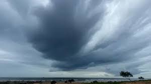
Formation of Low-Pressure Systems Over Over Bay of Bengal
Low-pressure systems affecting Odisha primarily originate in the Bay of Bengal due to a combination of warm sea surface temperatures, atmospheric instability, and the presence of the monsoon trough.
The Bay of Bengal's warm waters, especially during the pre-monsoon and monsoon seasons, provide the necessary heat and moisture to fuel these systems.
When the sea surface temperature exceeds 26.5 degrees Celsius, it facilitates the rising of moist air, leading to cloud formation and precipitation.
The convergence of winds at the surface and divergence aloft further enhance the development of these systems. Once formed, these low-pressure areas can intensify into depressions or cyclonic storms, depending on the prevailing atmospheric conditions.
ALSO READ: Low pressure becomes less marked; IMD issues orange and yellow alert for thunderstorms in Odisha
Inconsistency of Low-Pressure Systems in Summer 2025
The summer of 2025 has been marked by an anomalous weakening of low-pressure systems over Odisha. Several interrelated factors have contributed to this phenomenon:
Persistent Heatwaves: Odisha has experienced an unprecedented number of heatwave days this summer, with forecasts indicating up to 44 days of extreme heat during the March to May period.
The dominance of hot and dry northwesterly winds has led to elevated temperatures and reduced humidity levels, creating an environment less conducive to the formation and sustenance of low-pressure systems.
Atmospheric Stability: The prevailing atmospheric conditions have been characterized by stability, which suppresses vertical air movement necessary for cloud development and precipitation. The lack of significant temperature gradients between the surface and the upper atmosphere inhibits convection, a critical process in the intensification of low-pressure systems.
ENSO-Neutral Conditions: The El Nino-Southern Oscillation (ENSO) plays a pivotal role in influencing weather patterns across the Indian subcontinent.
Currently, ENSO-neutral conditions prevail, meaning neither El Nino nor La Nina is dominant. This neutrality can lead to less predictable and often subdued monsoonal activity, affecting the development of low-pressure systems over the Bay of Bengal. (NOAA)
Dry Air Intrusion: The intrusion of dry air from the northwest has been observed, which hampers the moisture availability necessary for the sustenance of low-pressure systems. Dry air inhibits cloud formation and can lead to the dissipation of existing systems.
Case Study: The April 2025 Low-Pressure System
In early April 2025, the India Meteorological Department (IMD) reported the formation of a low-pressure area over the southwest Bay of Bengal. Initially, there were concerns about its potential intensification and impact on coastal regions, including Odisha.
However, the system failed to strengthen significantly and resulted in minimal rainfall. Meteorologists attributed this to the prevailing high temperatures, dry air intrusion, and lack of supportive atmospheric conditions.
The system's inability to draw sufficient moisture and energy from the surrounding environment led to its rapid weakening.
Implications and Future Outlook
The weakening of low-pressure systems over Odisha has significant implications for the region's water resources and agriculture. Reduced rainfall can lead to water scarcity, affecting crop yields and accelerating drought conditions.
.jpg)
.jpg)
.jpg)
.jpg)

.jpg)